Ecology
Ecology...'State of the Canyon'
This State of the Canyon message is a new concept adopted by the Spearfish Canyon Foundation to provide meaningful information to the multitudes that are endeared to the unique scenic splendor of Spearfish Canyon.
Spearfish Canyon is recognized as one of the premiere natural landscapes in America. It is a State and National Forest Scenic Byway, and was recently nominated as a National Scenic Byway.
As is warranted, the Spearfish Canyon Foundation will issue a comprehensive report reviewing the significant features and activities that are important to the understanding of the Canyon's health, safety, enjoyment, and preservation.
The Foundation believes that through the comprehensive understanding of the Canyon, the public will be drawn closer to its appreciation and thoughtful caring.
Spearfish Canyon-An Overview
Spearfish Canyon is twelve times older than the Grand Canyon. About 90% of the Canyon is part of the Black Hills National Forest. The Canyon is 20 miles long and typically a mile wide comprising about 11,500 acres. State highway, 14A and Spearfish Creek traverse in parallel along the Canyon floor. Elevation of the canyon floor ranges from 3,700 to 5,400 feet. The Canyon’s limestone high walls tower about 1,000’ above the Canyon floor.
Recently, a DOT Corridor Management Plan (CMP) and USFS Landscape Assessment were developed and adopted through the participation of numerous and varying organizations with interest in Canyon affairs. This ‘consensus of use and enjoyment’ and 'priority of proposed projects' are intended to serve as a guide to federal and state entities that manage the vast majority of the Canyon.
History
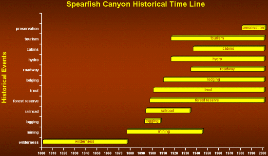
The recorded history of the Canyon dates to the discovery of gold in the Tinton and Lead areas of the Northern Black Hills in 1876. Mining, logging, and, eventually, recreation, are the primary activities that opened the Canyon to public consumption.
The Canyon was a wilderness until the discovery of gold in 1876. A number of mining ventures were established in the area. The last Canyon mining operation was Spearfish Cyanide near the rim at Johnson Gulch.
Logging began in the Canyon in 1892 with the establishment of the McLaughlin (Tie & Timber) sawmill at Savoy.
In 1893, the Burlington Railroad constructed rail service through the Canyon from Deadwood to Spearfish.
President Grover Cleveland nominated the Black Hills as a Forest Reserve in 1897, and in 1905 the Reserve became the Black Hills National Forest.
In 1909, the Savoy sawmill was sold and established as the Glendoris Lodge, and in 1919, renamed Latchstring.
Tourism began in 1910 with the establishment of the Glendoris Lodge.
A major flood in 1933 washed out major portions of the rail bed at Iron Creek, and in 1934, the first roadway was built through the Canyon.
Homestake Mining Company constructed a hydroelectric system in the Canyon in 1916.
Cabins first appeared in the Canyon in 1936 under permits from Homestake Mining.
In 1989, Canyon preservation activities began with a major land trade between Homestake and the National Forest. Later activities included the Dunbar land trade and the acquisition activities of the Spearfish Canyon Land Trust.

Visitation
The noted architect Frank Lloyd Wright acclaimed the Canyon more magnificent than the Grand Canyon in his visit of 1935.
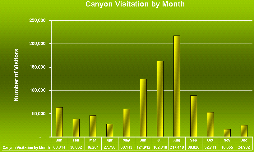
Through data interpreted from the State Departments of Transportation and Tourism, it is estimated that nearly a million people visit the Canyon annually. This level of visitation ranks the Canyon as the fourth most popular attraction in the Black Hills.
Canyon visitation is seasonal with predominant visitation in July and August. Modest increases in winter visitation are occurring due to snowmobile activities. The entire Black Hills snowmobile trail is rated by some national accounts as the second best snowmobile trail system in America. A popular, but limited sized, snowmobile trail-head is located at Savoy.
Canyon visitation appears to be a function of and proportional to tourism patterns of the entire Black Hills region.
Recreational Activities
There are significant multiple use activities in the Canyon because of its four season access.
Scenic driving is by far the most predominant recreational activity in Spearfish Canyon. In 1998, nearly 355,875 vehicles drove the Canyon Byway. About 17% stopped at the Latchstring to eat, visit, hike, or simply admire the scenery.
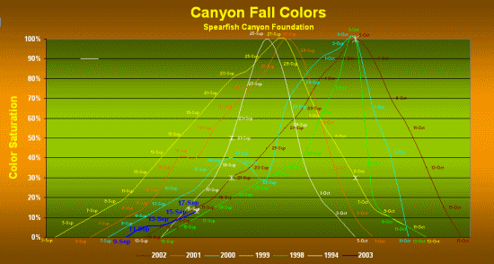
By far the two most intense periods of recreational driving is the Sturgis Motorcycle Rally in August and the Canyon's fall color display in mid September through early October.
Bicycling appears to be the second most popular recreational activity followed closely by jogging. There are many bicycling and jogging charitable fundraising events each year that are conducted along the Byway.
Recently, the Canyon Scenic Byway was recognized as one of the 50 top bicycling routes in America.
Fly-fishing appears to be the next most popular recreational activity. Hiking and mountain climbing are also very common. Camping is the least recreational activity because of limited facilities.
Two nature-hiking trails, Needle’s Eye and Buckhorn, are encouraged for future development. Existing trails include the three quartermile Spearfish Canyon Floor Trail to Spearfish Falls, the one-mile, handicapped accessible, Roughlock Trail to Roughlock Falls, and the challenging three-quarter mile ’76 Trail to the Canyon rim at Buzzard's Roost. The Canyon’s five acre Native Botanical Gardens is near full development.
To date, $230,700 has been spent on public environmental education projects comprised of three nature hiking trails and native botanical gardens…$148,000, or 64%, from the Spearfish Canyon Foundation, $48,000, or 21%, from the National Forest, and $34,000, or 15%, from SD Game, Fish & Parks.
Major charitable contributors to the Foundation for these projects are the South Dakota Community Foundation and the Kind World Foundation.
Public Safety
Fortunately, few lives have been lost in the Canyon; although over 200 accidents have occurred resulting in nearly 140 injuries. The Canyon attracts a strong mix of multiple uses and many of these activities tend to co-mingle in the same areas.
The Scenic Byway is a state highway allowing for commercial and personal vehicular use ranging in size from 18 wheel transports to 2 wheel motor cycles. Less than 10% of the average daily traffic involves commercial vehicles. Simultaneously, joggers, bicyclists, and hikers share the 24-foot roadway with 4-foot wide shoulders from Spearfish to Savoy. The road narrows to 22-feet with no shoulders between Savoy and Cheyenne Crossing.
The 35 mile per hour speed limit appears sufficient to safely navigate the winding corridor. Because of the mix of traffic, rockslide debris, the frequent appearance of deer, mountain goats, and other wildlife, and a large number of scenic drivers who slow to enjoy the view, speed enforcement is encouraged.
There are forty-one pullouts along the Scenic Byway. The popular pullout at Bridal Veil Falls causes dangerous traffic congestion. The CMP urges the construction of a visitor platform to provide visitors a safe viewing area rather than the current use of the roadway shoulder.
Rock slides and high water events are common along the roadway as the Canyon continues its relentless formation. The effects to the roadway can cause very dangerous conditions. South Dakota's DOT performs an exceptional job of keeping the roadway clear of natural debris including rocks and snow. In all, South Dakota DOT spends nearly $100,000 a year on the Canyon Byway.
Byway Beautification
Litter is a continuous problem along the roadsides and at pullout areas. Thanks to the charitable efforts of twelve local civic organizations, volunteers twice a year patrol the area. Fast food wrappers and beverage containers make up the majority of debris. Through observation, high school and college age citizens who frequent the Canyon for social purposes cause the majority of littering.
There are 237 roadway signs plus 69 fire markers along the Scenic Byway. The majority is traffic signs of the Department of Transportation. The CMP urges DOT to review the necessity of so many signs without diminishing safety considerations. Recently, the twelve Adopt A Highway organizations unselfishly agreed to allow DOT to cluster their recognition signs at both ends of the Canyon.
The CMP addresses a number of other aesthetic issues to enhance the natural look of the Canyon. Garbage dumpsters, realty for-sale signs and other urban-type structures are encouraged to be removed from the public right of way and/or screened from view.
Public lands of the National Forest that border both sides of the Creek are encouraged to be left in their natural state and not manicured to urban type lawns.
Ecological Health
The environmental health of the Canyon is considered good, although concerns exist for trending conditions.
Weed infestation was occurring at an alarming rate and is a current priority concern. In the seven years ending in1999, weed management had been neglected, mainly because of numerous complaints from Canyon landowners. The CMP, and most recently, the County weed management plan have addressed the issues. Canyon organizations and public agencies are currently working a coordinated long term management plan.
The forest is predominantly comprised of Pine, Spruce, Aspen, Birch, and Oak. Since no logging practices have occurred in the Canyon for the past fifty years, the forest has become quite dense with fallen timber debris. Such a condition invites three trending concerns. First is the increased fire hazard. Second is the vulnerability to beetle infestation. Third is the crowding and resulting destruction of diverse vegetation.
There is evidence of expanding infestation of spruce and pine trees by the bark beetle, red turpentine beetle, and pine beetle. Spruce broom rust and lichens are two fungi commonly found in the Canyon.
Although the Canyon is identified separately in the US Forest Service’s 10-Year Plan, Spearfish Canyon as a National Forest Scenic Byway does not receive any special or unique management or funding beyond what is provided for the entire National Forest. It proportional annual management expenditures are about $50,000. The recent LA was conducted by the Forest Service to establish priority management criteria that will be followed by NEPA decisions.
The National Scenic Byway designation provides an opportunity for federal funding to address environmental concerns, like removal of fuel to diminish fire hazards, management of noxious weeds, botanical and biological studies and enhancements, and educational, recreational and safety projects.
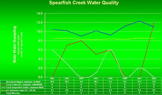
The waters of Spearfish Creek and its tributaries are generally considered of good quality. Current development and the dominant limestone bedrock have not negatively affected water quality. The best evidence of good water quality is the flourishing population of mountain stream trout. Over the past decade, dissolved oxygen, fecal coliforms, suspended solids, and pH have been better than state minimum standards.
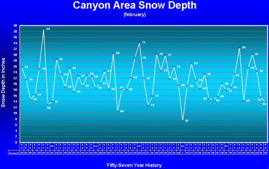
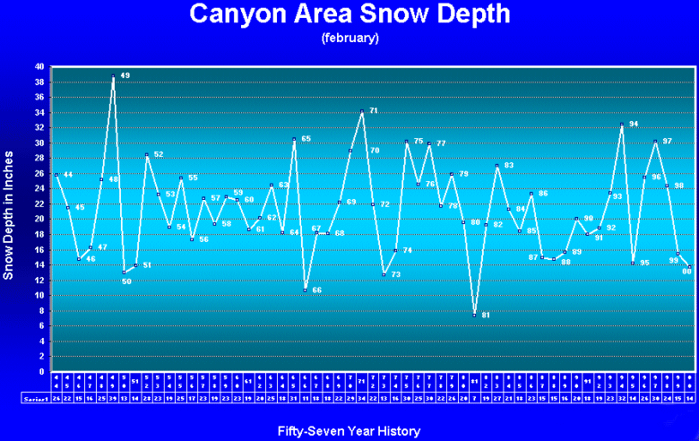
The Canyon area receives about 28 inches of moisture annually. On average, about 70 inches of snowfall occur each year. The depth of snow for the Canyon area (O’Neil Pass) has been recorded each February for fifty-six years. This historical record reveals interesting variations of snowfall by decade patterns. By evidence of active springs and seeps in the Canyon area, the recent decade is experiencing a high moisture level.
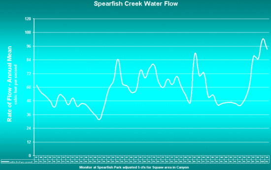
Water flow in Spearfish Creek has experienced a marked increase since the late forties and fifties. According to U.S. Geological Survey Canyon monitoring stations, the annual mean flow of Spearfish Creek near Squaw Creek is 53.9 cubic feet per second over the past half-century Seven of the seventeen gulches that empty into the Canyon contain perennial streams. A few others flow seasonally.
The Canyon is comprised mainly of Madison limestone and near the lower end of the Canyon, outcropping of the Madison aquifer is visible. This massive underground watercourse provides significant drinking water resources to numerous communities throughout the area.
Wildlife/Botanical Values
The Canyon contains a unique convergence of four biomes, plant communities, that provides an unusual array of 1,260 species of vegetation.
The most pristine areas in the Canyon are contained within the remote gulches that merge at the Canyon floor along the twenty-mile route. These environments are well protected from the extremes of weather and public intrusion. Such sensitive plants like the Fairy Slipper orchid and Lady Fern are found.
The diversity of plant life allows for a wide array of avian and mammal populations and species. The Canyon is home to many small mammals including a dwindling population of beaver.
Wildlife in the Canyon is a function of habitat beyond the rim. There is limited pasture areas in the Canyon to sustain large mammals and raptors that frequent the Canyon scene. Whitetail and mule deer, elk, mountain lions, golden eagles, vultures, hawks, and “one” mountain goat are common.
The Canyon contains 130 species of native and migratory bird populations. A small population of American Dipper is found predominantly at Roughlock and Spearfish Falls while large populations of songbirds are found throughout the landscape.
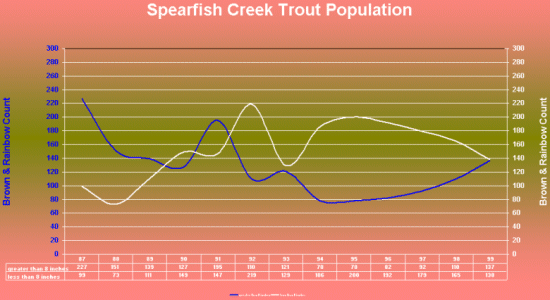
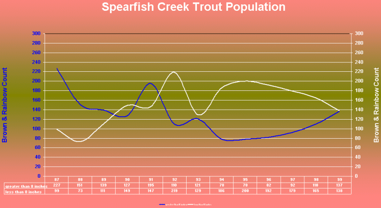
Spearfish Creek is the only permanent fresh water stream in South Dakota that sustains a self-producing wild population of Rainbow trout. Trout were introduced into the Canyon in 1900. Historical records of fish counts by the South Dakota Department of Game, Fish and Parks show an impressive population of rainbow, brown, and brook trout.
South Dakota Department of Game, Fish and Parks has spent nearly $300,000 in the last decade to monitor and enhance Canyon habitat. The Foundation has participated in and helped fund a number of these improvements.
With the completion of the Canyon land conservancy project, the Foundation contemplates turning its priorities to wildlife and habitat enhancement projects including a Bird Sanctuary, Butterfly Gardens, and beaver, trout, golden eagle, peregrine falcon and mountain goat.
Gone from the Canyon scene since the early forties are timber wolf, grizzly bear, black bear, mountain goat, and peregrine falcon. The golden eagle no longer nests in the Canyon and is only found during its winter migration to the area.
Development and Preservation
It is a condition of human character to assume the present scenic values and environmental qualities of the Canyon will continue to prevail unabated into the future. Urban sprawl is threatening to change the Canyon landscape, and it is difficult for most locals to recognize its peril.
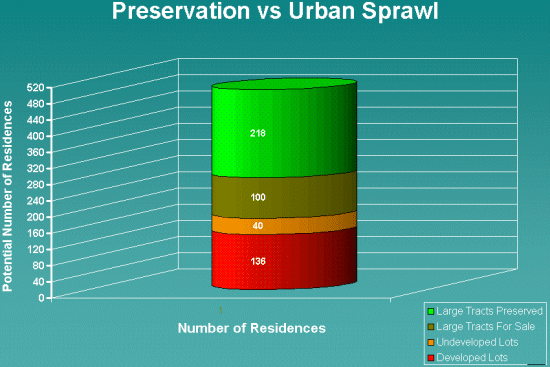
Currently, there are 152 homes, 48 undeveloped lots, and three commercial properties in the Canyon. Success of the Spearfish Canyon Land Trust will prevent nearly 240 additional homes from being constructed in the Canyon environment. The public will benefit from preservation of the scenic values of the Canyon and the eventual increased numbers of wildlife through enhanced habitat.
As of March, 2003, the acquisition goal of 1,100 acres is 60% complete with acquisition of 647 acres of undeveloped large tracts. The National Forest and the Land Trust are coordinating efforts and resources to accomplish the preservation project by the end of 2003.
Nearly $1.2M has been spent in Canyon land conservancy ... $220,000, or 20%, by the Land Trust, and $953,000, or 80%, by the National Forest. When the project is completed, public owenrship of the cayon will increase to 97%.
Through a recently adopted county comprehensive plan, it is unlikely that new commercial development sites will ever occur in Spearfish Canyon. Modest expansions may take place at the three existing commercial facilities at Cheyenne Crossing, Savoy, and Rim Rock.
Economic Development
Spearfish Canyon is an asset to economic development in the local and regional economy. The Canyon is a unique natural attraction that extends the travel duration of the Black Hills visit. It is doubtful that travelers come to the Black Hills solely to visit Spearfish Canyon. The Canyon is a scenic corridor connecting the tourist trades between Spearfish and Lead/Deadwood, and onward to attractions in Wyoming.
The most popular Canyon attraction is Roughlock Falls. It is pictured in most state promotional travel literature.
|